|
|
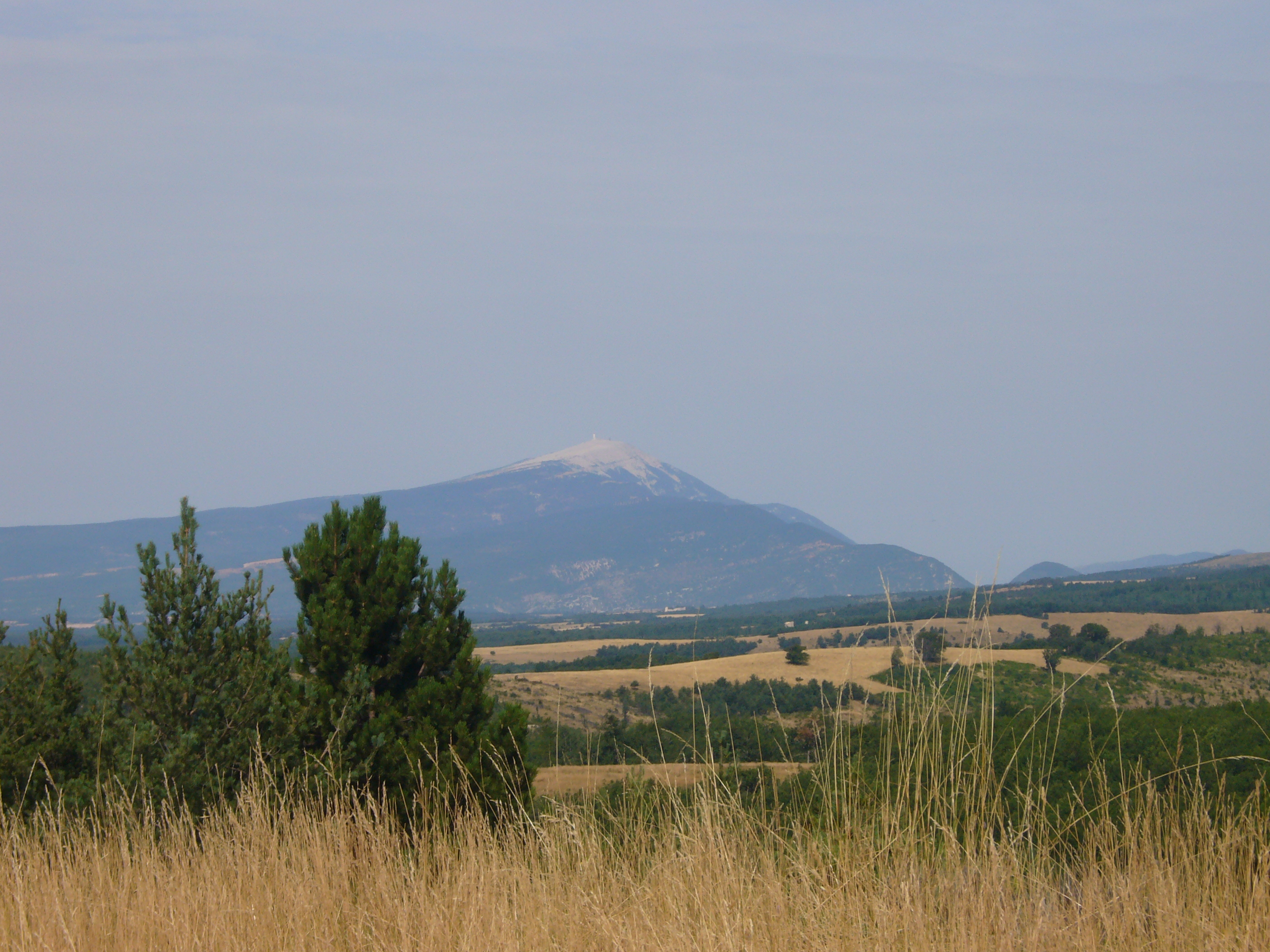
| Mt. Ventoux from Le Contadour |
NOTES ABOUT
VENTOUX-LURE WALK AUGUST 2007.
We
did this challenging 3-day walk 8-10 August 2007.
Day 1: Bedoin to Montbrun-les-Bains
via the summit of Mt. Ventoux and across the entire west and east ridges. Six walkers started up the GR 91B from the bottom
of the Combe de Maleval, 2 kms north of Bedoin, at shortly before 0800. They were: myself, Christopher MacRae (then aged
70) and my grandson Niki MacRae, aged 15 (we were the team originally envisaged); plus Callum,13 (Niki’s brother
who was keen to do as much as possible of the entire 3-day walk); plus, coming for the first day only, Christina MacRae (the
boys’ mother - and my daughter), Eric Payne (friend of Niki and Callum, aged 16), and his (Swedish) cousin Hanne
(aged 20). Although the summit of Ventoux was visible when we started, the weather was cloudy and uncertain. During
the ascent, it twice rained lightly; and cloud sometimes swept over the ridge as we were walking up it. Once we reached
the summit, we were looking down on a huge mass of cloud with only occasional glimpses of distant views. Things improved on
the way down to Montbrun-les-Bains, and we finished the walk in sunshine.
The climb up to the summit along the
west ridge was uneventful and went as planned, along the route described in the guide book to Mt Ventoux by Isabelle and Henri
Agresti. Having already done this walk in 2003 with Steve Stuart, I managed to avoid any navigational errors on the way up
(a climb of nearly1500m). But this mixed-ability group was not walking fast and needed to make several rest-stops. So
we did not reach the summit until 12.50 – almost an hour longer than it had taken me and Steve. Lunch-break for about
40 minutes at the summit.
We started down the east ridge at 13.30, reaching the Col de la Frache at 15.30. By then, some were finding the going
tough, and needed increasingly frequent rest-stops. How to get down off the end of the east ridge at La Tune, the last hill,
had proved a headache for Steve and me four years earlier, since the Agrestis’ book does not bother to describe it.
A year later, I had made a reconnaissance visit from the valley and had worked out a route along a forestry track which
zig-zags down from somewhere just below La Tune to the road below, near Reilhanette. But there were still problems with this.
First, it was hard to find the start of this track since there was no path at all from the end of La Tune for some 2 - 300
m, mostly down a steep hillside, partly on shale. Secondly, the zig-zags added a lot to the total distance. I managed to locate
the beginning of the track all right; but by then, the awkward descent on shale had taken its toll on weary legs. So the rest
of the descent along the forestry track got slower and slower as some of the group became tired.
Fortunately, we were able to contact the “back-up team” (consisting of John Zavos and Richard Payne) by
mobile phone and asked them to pick us up from where the tarmac began a couple of km from the end; but unfortunately, the
rules for the use of this forestry road had recently changed, and there was a barrier near the bottom… Nevertheless,
everyone was able to walk to the cars, although Hanne and Callum were by that time limping. We eventually reached the hotel/café
“Les Voyageurs” in Montbrun-les-Bains at about 19.30, where we joined Ulla Payne and Hanne Willert for a much-needed
drink – which raised our morale… Callum had done magnificently to have finished this long, tough walk; but
had now effectively ruled himself out of going any further. So after a while, everyone else went home, leaving just Niki and me to have dinner in the hotel where we then spent the night.
Comment on Day 1. Both the Arete Ouest Integral and the Arete Est Integral of Mt. Ventoux are well-known
walks that present no technical difficulty. The challenge is simply the total length of the walk (which I reckon to be 33
kms, plus an extra 1 or 2 kms for the zigzags at the end), together with the amount of climbing involved (about 1450m from
the start to the summit on the west ridge, plus up to another 200m on the way down the east ridge – where it has switchbacks).
The problem I have still not satisfactorily solved is how best to descend from the east end of the ridge. Maybe the easiest solution
is forget about going right to the end of the ridge, leaving it instead at the abandoned radar station at the west end of
La Tune, and taking the zig-zag path down from there towards Reilhanette. Even then, this great day’s walk is hardly
one for the faint-hearted…
Day 2: Montbrun-les-Bains
to the Jas des Terres du Roux above Le Contadour, across the Montagne d’Albion and the first part of the Montagne
de Lure. Niki and I were by now the only two walkers left. We started from Montbrun-les-Bains at about 0820, after
breakfast at the hotel. The route had three sections: Montbrun to the road at the Col de l’Homme Mort; the Col de l’Homme
Mort to the road at the Col du Negron; and from there to our finishing point above Le Contadour. At first the weather looked
potentially stormy - and we could see cloud over Mt Ventoux for most of the day; but it steadily improved. By the end
it was sunny but cold, with a strong mistral blowing.
The first section proved frustrating.
There was only one, rather sinuous, route shown on my map (TOP 25 3240 OT: Banon.Sault). We started up the road to Ferrassiere
(D.189) and successfully picked up the beginning of this unmarked path. But after 2-3 kms, the path had been fenced off, apparently
by someone who had acquired an old house near a sharp bend in the path. We spotted some spray-painted red blobs
on trees and bushes up the steep, shaly hillside above us, that this might indicate an improvised escape route. We scrambled
upwards, for a while until we reached a track high above our starting-point. But where was this on the map? We tried going
left for 100m or so, but this looked unpromising; so we retraced our steps and tried going right instead. Soon we reached
a small path leaving the track diagonally left, which could be what we were looking for. It looped round the
hill, in woods, for another 2-3 km. Then we reached a track at a sort of T-junction. Again we were unsure which way to go,
since there were no signs – in fact we saw none at all on this part of the walk. The track did not correspond at
all with the map; and we could not see where the Col de l’Homme Mort was. We decided to turn left, following the track
for 4-500m until not only were we going downhill but also, once the trees cleared enough for us to see anything, we realised
we were pointing towards Mt Ventoux – in entirely the wrong direction. So we retraced our steps and took the other direction,
to the right from the T-junction. Eventually, we could see what looked like the countryside on the far side of the Col de
l’Homme Mort (over which I had driven three weeks earlier). We had to make several choices between unmarked tracks none
of which appeared on the map; and I became convinced that we would hit the road (D 63) well below the col. However, more by
luck than good judgement, we hit the road exactly at the Col de l’Homme Mort. By then it was 12.15 – much
later than expected. The last hour or so had been demoralising since we were, frankly, lost. We sat down and ate some
lunch to regain our spirits.
Despite this unpromising start, there
still might be time left to reach our target. So after a half-hour break, we set off on the second section of the walk,
from the Col de l’Homme Mort to the Col du Negron. This time, the navigation turned out to be straightforward; but it
was a quite a long slog through unremarkable countryside, still part of the formless Montagne d’Albion. At least we
were rewarded by a view at quite close range (150 m?) of a large deer standing in the middle of a recently-ploughed lavender
field. Moreover, we reached our next target, the Col du Negron, more quickly than expected (at about 15.00?); so we decided
to press on to make our rendez-vous above Le Contadour as planned.
The third section of the walk was,
at last, on the Montagne de Lure itself. After some uncertainty about where the path took off from the D 18 road, we had to
grind our way up 200m to the top of Le Jambard, the last-but-one hill of the Lure ridge, at its the westward end – hard
on the legs by that time. The rest of the walk was easy navigationally, and also very pleasant since it followed
the ridge all the way giving exceptional views to the north where the ground falls away steeply all the way along the mountain.
The path along the ridge was only sporadically marked, but was clear enough, and fairly level. By the time we reached the
Pas de Redortiers where we had to leave the ridge and turn south to reach the Jas about 2 kms further, above Le Contadour,
Niki was exhausted and kept going only through sheer grit.
We reached this beautiful dry-stone sheepcote, the Jas des Terres du Roux, at 17.30, half an hour before the
target time. Niki was able to contact the “logistics team” of John Zavos and Mette, accompanied by Christina,
Callum, Isla, and Hanne Willert. They were by then in Banon and at once drove up to meet us. We picnicked in the dry-stone
sheep-enclosure – rather chilly in the stiff north wind (mistral), and ate a delicious meal. Niki decided that he would
not be able to manage Day 3. So as the evening light started to fade, the others all drove off, leaving me to sleep on the
straw in the smaller of the two dry-stone buildings. It was a good thing I had chosen this one because before long, the owner
of the ferme-auberge Les Tinettes 2 kms further down the track to Le Contadour, and owner of the old Jas, turned
up to prepare supper for a group of about 30 randonneurs who arrived at 21.20 and did not leave until after 11.00…
However, the howling mistral meant that I could scarcely hear them at all next door. I slept well enough, though sometimes
woken by a mouse which was sharing the baguette provided for my breakfast and lunch next day, as well as gnawing my
apple…
Comment on Day 2. This was another very long walk, which I had calculated beforehand to be about 42 kms – to which could
be added 1 or 2 kms. for uncertain navigation. But it was easier than Day 1, mainly because there was less ascent involved,
although the climb up Le Jambard two thirds of the way through was hard. What I found slightly disappointing was that until
near the end, the views were for the most part much less grand than on days 1 and 3.
Day
3: the Jas des Terres du Roux above Le Contadour, to Peipin, over the summit of La Montagne de Lure and most of the
rest of the Lure ridge. I started
off alone at 08.15 next morning – unenthusiastic about starting earlier because it was still cold and windy.
However, it soon warmed up; the wind dropped; and the day became sunny and clear. No problem about finding the ridge, about
2.5 kms above the Jas. From then on, the walk was entirely along the long ridge of the Montagne de Lure, which continues
right to the end to be spectacularly steep on the north side, with magnificent views towards the Alps.
Although the map (soon TOP 25. 3341 OT: Montagne de Lure) did not indicate
a path on various sections of the walk, in fact there always was one – even if not marked, provided you stay
close to the ridge and remain vigilant. However, I had not examined the contour lines carefully enough beforehand, so had
underestimated the amount of climbing involved. From a distance, the ground seemed to rise gradually and evenly to the summit.
What this disguised was that there were a number of V-shaped dips which resulted in steep climbs, some quite long. The first
serious one involved descending through trees to the Col du Roche (over 100 m.), then toiling up the other side to the summit
of Le Treboux (about 250 m, some of it steep). Then came the Col St Vincent where I had to descend over 100 m. through trees
– and then climb up again 200 m, very steeply, on the other side, again mostly through trees, to the summit of Le Gol.
Even worse, since I was unprepared for it, was the Basse de Malcort – not even a pass!- which suddenly appeared between
the summit of Le Contras and the Sommet de l’Homme. The track down (about 250 m), was steep - and inaccurately shown
on the map. But the way up again (some 270 m.) to the Sommet de l’Homme was gruelling and even steeper. There were various
other less steep switchback climbs of 100-150m. too numerous to mention. I had predicted beforehand that this day’s
walk would involve only 3 – 400 m. ascent: I was quite wrong, since there must have been at least 1200m.
As a result, I did not reach the summit of the Montagne de Lure until nearly 1500, an hour later than expected. I
managed to phone home to say that my predicted arrival time at Peipin of 1700 was too optimistic, but that I should get there
between 18.00 and 19.00. Without spending enough time to admire the splendid view back to Mt. Ventoux - then clear of all
cloud, I set off down the east ridge of the Lure. This again had a clear path along the ridge (which is mostly quite narrow
and still extremely steep on the north side). The path was sometimes even quite well marked. Fantastic views again to the
north. To my relief, there was little uphill climbing to do. After about two and a half hours I reached the turn-off to Peipin
marked “La Faye” – which almost matched up with the map’s version of
“Gorge de la Faillee”: steep downhill most of the way. (Afterwards, I wondered if I would have done better
to take the “Chemin des Cotes”, a track which starts beside a new electronic relay mast, and which is probably
less steep.) I finally reached Peipin at about 18.30, where John, and Christina (plus Isla) were kindly waiting to drive me
home – a trip of two hours by car to Mormoiron.
Comment on Day 3. This day
was also at least 40 kms in length and more tiring than I had expected, mainly because of the unexpected amount of steep climbing.
At least no navigational problems. The views to the north and east were magnificent.
Overall comment. This whole 3-day long
walk of about 120 kms (plus an average ascent of c. 1,300m a day) turned out to be, as I had predicted, near the limits of
what a fit 70-year-old could manage. It proved beyond the limits of a fit 15-year-old, although Niki was heroic to get two
thirds of the way round the course. The route for the second and third days was entirely new to me, and I had not been able
to discover much about it beforehand. The second day was easiest – but
also the least interesting. A man we met at the Jas above Le Contadour, clearly an experienced local walker, said that some
randonneurs had done the summit of the Lure to the summit of the Ventoux in three days. Our version of the walk was harder,
since it included the ascent of Mt Ventoux from Bedoin (which took our initial group 5 hours), as well as the descent from
the summit of the Lure to Peipin (which took me 3-and-a-half hours). The summit-to-summit walk would certainly be less extreme.
I don't regret having taken the route we did - which may well have been a first; but shall try to avoid quite such an exhausting
one next time.....
|
